


Maps have always told us more than where we are or how to get where we’re going. Maps are “… representations of social and political aspiration and power, making statements about the ownership and control of territory.” *
The Art of Cartography, the current exhibition at the reference library’s gallery, features maps and atlases from the library’s special collections made during the 16thC to the 19thC. They demonstrate the ravenous, fill-in-all-the-blanks nature of the European age of exploration.


In those times maps were often drawn by cartographers who had not travelled with the explorers themselves but who, willing to forego verification, worked from accounts of explorers and from hearsay alone. Their excitement is palpable as their purview was broadening; still, their maps extended only as far as their own expectations. They encompassed what in the world the Europeans were looking for or where they were trying to go, entirely leaving out vast unknown landmasses. These maps, atlases and navigation charts are a snapshot of the European worldview at the moment it expanded to include the entire planet. Most are laughably inaccurate, but these are the beginnings of our age of precise satellite imagery.
Many of these maps depict not just the shape of the land, as much as they knew or thought they knew of it, but also illustrations of who was living there. The animals, imagined and drawn based on a few reported details, were fantastical and zoologically unrecognizable. 
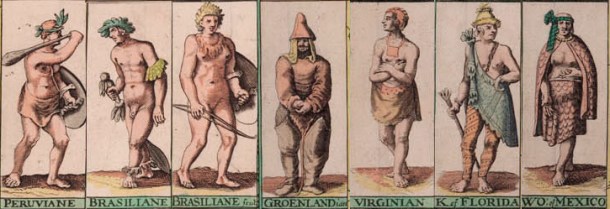 Native inhabitants were portrayed in a similar manner, their looks exotic yet somehow physiologically Europeanized. They look rather like specimen drawings, or is it just the knowledge of the ensuing plunder and devastation that gives that impression?
The exhibition inspired comparison to the work of a contemporary Canadian artist. Emma Nishimura’s art includes the drawing of maps that inform about the effects of politics on the geographical area portrayed. Nishimura is of European and Japanese ancestry, and her family history includes the internment of Japanese Canadians during WWII. She retraces that experience in the form of maps incorporating the least-imperial point of view – its victims. In her work, Canada’s west coast has borderlines composed of tiny hand-written text that tells us of the people who were once there but are no longer, how they came to be there and what they endured while there. Like those earlier cartographers, she too is working from recounted experience – it is her grandparents’ story, amongst those of many others. Accompanied by images inspired by old family photographs, she has embedded their story and our country’s history in the mapped outlines of the land itself.


The Art of Cartography is on until October 16, 2016 at the Toronto Reference Library.
Free admission.
Read more about Emma Nishimura here, and see more of her work on her website.
– Schuster Gindin
Photos by Schuster Gindin and courtesy Toronto Reference Library
